Travel Advisory:
How to Get to Baguio City
Baguio City is about 240 kilometers from Manila, the capital of the Philippines.
The entry point to the natural and cultural wonders of the Cordillera Region, and situated in the midst of mountains, hills and valleys, the City of Pines is accessible by land and by air.
This section will give you the most up-to-date ways of getting to the City of Pines, including recent changes in the usual routes folks have been accustomed to passing in the past decades.
Five major highways lead to Baguio City:
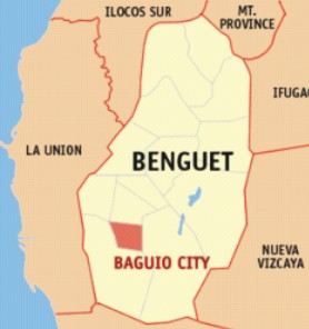
An government unit independent from the province, Baguio City is located completely within Benguet, and is the gateway to the vast Cordillera region of Northern Philippines.
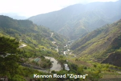
It is accessible from various mountain highway systems that folks call the "zigag" (but mostly this refers to Kennon road, the most popular of them all) that snake through scenic mountains and hills, following the courses of rivers and traversing bridges, to get to that interesting little place affectionately called the City of Pines.
1. Kennon Road has an entry point at Rosario, La Union, the old road that visitors from Manila and places south of the City of Pines love to take.
2. Marcos Highway has two entry points at Rosario and Agoo, both in La Union, and is favored for its wider lanes .
3. Naguilian Road is officially named Quirino Highway although no one really calls it that. Naguilian Road has an entry point at Bauang, La Union and is the road taken by travelers coming from northern Luzon provinces.
4. Halsema Road, passing through La Trinidad Valley - connects Benguet to Mountain Province (Sagada) and Ifugao (Banaue) and other places to the northeast.
5. Baguio-Nueva Vizcaya Road - connects Benguet to Aritao, Nueva Vizcaya, and is the newest access for those coming from provinces to the east of the city and is a great alternative to Halsema Road.
So now you see that there are really more than two ways to get to Baguio City, depending on where you are coming from. Halsema and Nueva Vicaya Roads approach the Summer Capital of the Philippines from the northeast, while Naguilian Road, approaches from the north, while Kennon and Marcos Highway approach the city from the south.
It is precisely this route that we will discuss next, as it is the one most traversed by folks coming from Manila, the capital of the Philippines. You will see how easy it actually is to get to Baguio City these days.
 | ||||
Manila to Baguio City: Easy as 1-2-3
NLEX-SCTEX
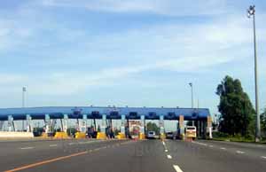
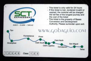
From Manila take the NLEX up to Exit 85, to get to the SCTEX. Shift to the right lane and head for Baguio via Tarlac (going straight takes you to Subic). Drive the length of the SCTEX until the Tarlac City exit where you will turn left to a country road. Drive about 10km more, following road signs until you reach MacArthur Highway
+/- 120km total
MacARTHUR HIGHWAY
Turn right to MacArthur Highway, pass through the remaining four towns of Tarlac province, and the length of Pangasinan province making no turns, till you reach Rosario, La Union.
+/- 90km
"ZIGZAG"
Turn right at the Rosario junction to Kennon Road or go a little further (about 500 meters more) & turn right to the new entrance to Marcos Highway.
+/- 30km/40km
1
2
3

North Luzon Expressway - Total toll fees from Balintawak (pay at Bocaue gate) to SCTEX (pay at Dau gate) is about Php180.00 for a sedan.
Helpful tips for travelers who miss the turn to the SCTEX or who prefer to pass through other provinces to get to MacArthur Highway, plus detours and alternate routes to bypass Urdaneta City in Pangasinan province.
Here folks, finally, is the answer to that million dollar question, the one that all my friends always ask before coming up! Personally, I prefer to pass Kennon Road because it is shorter and my Nissan Patrol can take the rough patches but. . .

"How long does it take to get up to Baguio?"
By private transport, the trip from Manila usually takes just 4-5 hours during the day, and sometimes less at night. After all, the Summer Capital of the Philippines is just 240-250 km away.
Night travel is much faster because there is less vehicular and pedestrian traffic, and fewer slow-moving public utility tricycles in the lowland provinces of Central Luzon plying their routes at night. Plus it is easier to overtake when you can see the headlights of oncoming vehicles.
(But that's just me. I prefer night travel.)
WARNING!!!
Beware of Baguio Guide books being sold in the city that copied information from this page without my permission. The travel advisory info they copied has been rendered obsolete by the new -- and faster -- SCTEX route.
The Subic-Clark-Tarlac Expressway is one of the best things to have happened for travelers to the City of Pines. It has cut travel time considerably because this new highway bypasses the traffic-congested towns of nothern Pampanga and southern Tarlac provinces in Central Luzon, Philippines...
ALERT! Rosario Bridge fully repaired :)
The bridge connecting Sison, Pangasinan to Rosario, La Union (which is the entrance to Marcos Highway & Kennon Road) is fully open.
Folks will no longer have to use the Bailey bridge or pass Urdaneta-Damortis to get to Rosario, La Union.

Quick Links
©2012. All Rights Reserved. GoBaguio! Your Complete Guide to Baguio City, Philippines
Did you enjoy this page and find it useful?
SHARE!

GET EVEN MORE FROM US!


